UM/270/2019/LiDAR

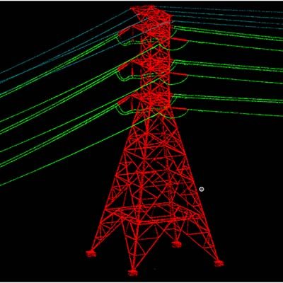
UM/314/2020/LiDAR Duration: 4 weeks (1200 Hours) Yaer: 2020 Length : 500 Miles Total Manpower : 10 Location: USA Service Type: LiDAR Objective The objective of the project to classify all Power line related structures. Inputs Calibrated raw point cloud in LAS format Tile layout in DGN format Point Class file in PTC format Orthophoto In…

UM/314/2020/LiDAR

UM/314/2020/LiDAR Duration: 12 weeks (1800 Hours) Yaer: 2020 Area : 1500 km2 Total Manpower : 8 Location: Germany Service Type: LiDAR Objective The objective of the project is to classify the LiDAR data for low points and air points filtered and the ground Classified using automated Terrascan algorithms. However, the data required Validation and editing…